Cherry Valley
Info
Classic PNW lowland temperate XC/AM singletrack. Most of the trails are bike-focused, with some fast and tight sweeping turns, little drops, lots of roots, and some technical areas. In general, the trails have a narrow corridor, shorter sightlines, and intermediate-level tech.
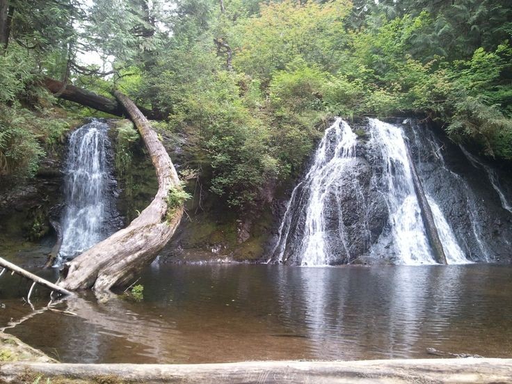
Some of the property is private although it is backed up by Marckworth State Forest and Hancock Timber property. The system is a mixture of logging roads in various stages of use and user built singletrack. It mostly is on the north side of Cherry Creek, leading up the hill to Lake Margaret. Highlight of the ride is the falls on Cherry Creek, upstream from the main riding area. A must do on hot summer days. Area can accommodate beginners.

To hit most of the gems out here, try the following 2-hour loop (referencing the attached map and looking for the signs at the ends of the major trails):
Start heading NE on the forest road up and around to the bottom of Elevator, which you'll then find on the right. Elevator is a billed as a climbing trail. It has a long series of moderately-challenging switchbacks that take you up to the top of the road that leads towards more of the fast, downhill-oriented trails. Although generally packed and smooth, there are a number of roots and gnarly sections that make it a respectable challenge to climb without dabbing.
Head up the road and take a right, then look for Funner on the right. This is an up-and-down downhill trail, with some fast technical descents and a few mild and short climbs. There's an intimidating ladder bridge elevated about 5' above the creek at one point, as well.
Go right on the road and remain right to loop back to the start of Elevator. Take it again (and try to clean it this time!), and then head left and keep a look out for the start of Cyclops. Cyclops is similar to funner, but longer and faster.
At the bottom, you can either go right onto Bobcat, or left back to the forest road just across from the bottom of Elevator. If you take Bobcat, you'll have a potentially deeper creek crossing, and the trail is generally not as well-used as the others. You'll turn right at the road and head up. If you do not take Bobcat, and instead exit Cyclops back on the forest road, then you can either climb Elevator a third time (and really try to clean it this time!) or just save a bit of time and climb the road.
Regardless of your choice above, you'll eventually climb one of the two forest roads that parallel each other (with the creek in between them), to the top of YGD. If you took the eastern forest road (via elevator or otherwise), then you'll cross a wood & dirt bridge that goes over the creek, and find YGD on your right. If you came up the western forest road (from Bobcat), then you'll find YGD on your left just shortly before you encounter the aforementioned bridge.
Descend YGD - which is similar to Cyclops in nature - until you reach Sick and Twisted.
Sick and Twisted is generally more flat and mellow, but has a few exciting features, such as a small ladder, a large rock rollover, and some sweeping turns. Follow this to No Road.
Take No Road, which is mellower than Sick and Twisted and largely flat, until you reach the forest road that you started out on.
Begin descending the forest road back to where you parked, but after the first steeper descent, look to your left for Black Label. Take this trail, staying left at the two minor spurs. Black Label is similar to Sick and Twisted as far as rate of speed and technical factor. It will spit you out back on the forest road just above the parking area.
Photos
Videos
Trail Status
Ride Reports
Today I got to the trailhead about 8am and had an enjoyable ride heading out to do Funner and Outer Limits, then out to the Falls, and then back up to do Barracuda where a chainsaw is needed two thirds the way down still. Climbing roads have trees too. After Barracuda I climbed Funner to the...
The last week I've been on a staycation SE of Monroe at the Thousand Trails, Thunderbird RV Park on the Skykomish. I had my bike with me and took the challenge to get to the Cherry Valley trail system from the North, using Ben Howard and Cedar Ponds Road. The goal was to do the Outer Limits trail...
I went out to Cherry Valley Friday to enjoy the dry day and the early Spring like weather. I ended up doing most of the main trails and finished with Outer Limits, Little Ridge and Black Label. The trails were all in good shape but Outer Limits really needs to be hardened and the organics removed...
Took the bike to Cherry Valley, east of Duvall,WA this morning to take advantage of one of the best draining trail systems around Puget Sound. The access roads can be a bit wet or icky but once you start your trail runs you only had to be careful on the wet roots. I climbed Sick and Twisted and W...
Went out to Cherry Valley this afternoon to take advantage of the moist soils and refamiliarization of the Outer Limits trail. I first went to run Funner and cleared the tree and logs across the upper third. Then went over to Barracuda and took a second run on the log 'step up' successfully. Then...
Went out to Cherry Valley this morning to take advantage of it's great resilience to our recent rains. Darrington's and Cherry Valley's trails are my first choices for post-storm riding. The roads may not drain in spots but the trails in the thick foliage are constructed well with strategic drain...
Took advantage of the beautiful day and went on Burnt Cedar, Outer Limits, out to the Falls for a couple of pictures, and then Barracuda and Funner. The wet roots got me twice today and the second time was on Funner, ironically. I went OTB and my glasses lost a lens but I found it immediately and...
Caught the break in the rains and went to another of the 'best draining' trail systems in Puget Sound, Cherry Valley. The access road is wet but the trails are good. I had to go around an early morning accident on Cherry Valley Road by going east on Big Rock Road and then North on Kelly Road to t...
I saw a newer technical trail called Outer Limits on Trailforks and decided to try that for the first time this morning. I climbed Waterbars Up, and then went over to Burnt Cedar to do that trail "out and back" and then down Outer Limits. It is a little soft still and needs a good packing. I went...
Had a wonderful morning with a friend from work doing Barracuda, Escorlator, Funner, Cyclops, and Sick and Twisted. All were clear with some slick spots but they were all fun. After the friend left I went out to the Falls for the picture and water. The crossing for folks using the road route to t...
Started today at 7am at the trailhead with the goal to head to the Falls, and then further on to the old Platts Lookout site, a 900' summit, east of the Falls, then exit the south side of the Marckworth Forest and back to the car. The ride went well to the Falls except for a couple trees across t...
Had a wonderful time going up and down, west to east, over the trail system and then off to the Falls for a little rest and tranquility. There is a DNR sign at the trailhead announcing a cougar sighting at the Falls. The bike trails are in great shape EXCEPT for the bridge across the Gully Bypass...
I wanted to explore more of the Marckworth Forest and mapped out the loop in the image. After making it to the Falls, the road farther east has been worked on and some water and vehicle traps have been added. The road was graded and pretty soft but passable. I tried one shortcut to get to Stossel...
Tried to see if I could see the falls with all the snow melt going on but could only make it a little farther than the trail/road intersection elbow about 2/3 of a mile short. Snow has weighted down a lot of saplings over the trail making many obstructions and handlebar grabbers. Traction was onl...
As previously noted, the trails are great and the Falls are beautiful. Did the Falls first and then Escorlator, Elevator, Little Ridge, and then Funner and Cyclops under lights. It was a great evening and the only thing this area is needing is a wonderous view of the sunset. I saw the pink throug...
Bob has been giving these trails some much needed love and it really shows. Overall improvements in drainage and surface work are awesome. These trails are in the best shape we've ever seen. Clean, glorious, hero dirt right now. The access roads are a bit muddy, but who cares. Great day playing i...
Generally in good shape. Elevator was a bit overgrown in places, wear long sleeves or let the thorns take the difficulty up a notch. Thanks to whoever took a weed wacker to Sick and Twisted, looks like that had just happened in the last day or two.
Did the usual 2 hour ride and nary a substantial mud puddle. Still organic debris on the trails but nothing a raking or leaf blowing won't cure. Trail corridors are in there usual mid winter wide open state. stream crossings where the DNR took out culverts are running well but still able to cross...
My son and I really enjoyed our ride today, mostly. The trails were a bit overgrown but passable. The road-grade trail out to the falls is rough and a bit overgrown in places but still the preferred option to get to the falls. The single-track trail coming back from the falls (parallels the road-...
Rode here for the first time in 2016 and the record winter rains have made mother nature very fruitful. I spent a lot of time cutting back the foliage and leafy handle grabbers. This is a great area just east of Duvall with a neat side trip to the falls for the summer. Come help clear the new gro...
Trail conditions were generally good, but it's clear the trails are getting a lot less use than would be expected for this awesome stretch of weather: a lot of organic litter in the trail corridor (branches, twigs, some of substantial size), and getting a bit brushy (hey, it's spring after all)....
Solo ride this morning at Cherry Valley. Saw a handful of hikers, but nobody else on bike. The trails were amazing - what little water present was in solid state, and there were no obstacles anywhere (except a fallen tree only partially blocking part of YGD). However, the creeks...
Returned to Cherry Valley for the first time since the last school year ended. Great to be back, and conditions did not disappoint! Totally clear everywhere - no blowdown, and every single creek crossing was bone dry, except for the big one with the log/dirt bridge up top at the start...
This will be my last ride & report at Cherry Valley until probably September. It was an absolutely perfect day out there today: pleasant temps, hero trails, and cool shade under canopy. The brush is coming in with a vengeance - salmon berry, grass and bracken ferm mostly. Creek...
Started this ride at the Cherry Valley parking area and headed east to the falls and kept going all the way to the top of Mt Stohr. The continuing road is in good shape with no obstacles to overcome except for a gate covered with logging debris. It’s easy to get around though. You continue on eas...
Don't let the warm clear weather fool you; the recent rains reactivated a lot of the muddy areas and turned the forest into a steamy jungle. I think I saw Michael Douglas and Kathleen Turner hacking their way to Cartegena! The upper trails are all in good shape - great, aside from som...
Elevator is 100% clear and in prime shape.
Escorlator is about 95% - there is one big tree still across the trail, and in the vicinity a lot of raking would be helpful.
Funner is 100%.
YGD has 1 small (8") flow-buster across the trail. Otherwise prime.
Sick &...
After the carnage from last Sunday, and the dismal ride Monday evening, I was astounded to see how amazing the trails looked today! I rode Elevator, Funner, Escorlator, YGD, Sick & Twisted, No Road, and Black Label. Everything was great, except Escorlator, which still has a lot of blow...
The wind storm of 1/17 - 1/18 did some heavy damage out here. The good news is that I didn't see any damaged features, and the trail bed is in good shape (actually, the muddiest/worst I've seen since I started riding out here last fall, but that's not saying too much given this area is pret...
Trails in great shape! No mud sections of significance, but a few soft spots and bruises here and there. No blowdown.
Was a nice ride but the roots and climbs were pretty slick.
A catalog of my GPS tracks are at http://myplace.frontier.com/~valenti.seattle/GPS%20Files/
Did an early morning ride before the Pineapple Express. The trails were damp in spots but solid. Cleared a couple fallen snags on YGD. Cyclops and Funner were neat. After the mtb trails I rode the road out to the Cherry Falls and then back along the hiking trail. The creek crossing at the road wa...
Elevator, Cyclops, YGD, Sick & Twisted, No Road and Black Label - all clear, all in great semi-frozen shape. Will degrade a bit when it warms up, but these really are great winter options. No pooling or puddles.
Rode Elevator, Funner, Elevator, YGD, Sick and Twisted, No Road, Black Label. Still just as good - actually even better - than last week. Thanks to the locals for continuing to do maintenance out here; no blowdown anywhere.
Got a quick post-work ride in at Cherry Valley today, hitting: Elevator, Cyclops, YGD, Sick & Twisted, No Road and Black Label. All the trails were in amazing shape - no mud or puddles anywhere except a few teeny puddles on No Road and the actual doubletrack road climb. A bit slic...
Technically this was my second time out here, but really the first time on a "real" ride. Recent brushing + the new signage made this very approachable for a newbie, and the trail conditions were very good. Quite a surprise at how rad YGD was; definitely a fun and moderately technical...
Signage is up and seems to be staying up so far. Some locals not happy about letting the word out.
All the upper trails are in great shape and draining well. Lower trails like Sick and Twisted, No Road, and Black Label are getting the last summer brush out for the fall/winter/spring seaso...
Hope to have some signage out there soon to correlate with the map. There are several other trails out there with no name at this point but getting the noted ones signed should happen soon. More brushing will happen this week as well. Getting more and more popular with the hiking community since...
Reminds me of what riding was like when I first started in the 80's. Went up Escalator (challenging rooty turns and some rocks), down Funner (a couple places where it helps a lot to carry speed into the techy part), left up road and back to Cyclops (super fun has it all trail), across Bobcat Alle...
Decided I didn't want to fight I-90 traffic today so I ended up at CV for a few hours instead. Funner was riding nice, though starting to get a bit overgrown near the bridge and up top. Cyclops was really nice until until the bottom where it too was getting pretty overgrown. Elevator had some tru...