North Teanaway
Info
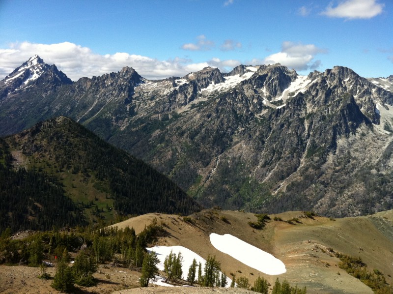
This area takes you on singletrack along refreshing creeks, mountain ridgelines and alpine scree fields. The riding can be quite technical as most of the trails are old school hiking trails with challenging rock gardens, steep grade and tight switchbacks thrown in for good measure. It rewards you, however, with breathbaking views of the Stuart range, wildflowers in spring and an incredible outdoors experience overall.
The trails are typically dry. Pine trees in the lower elevation areas provide some shade, and water is available in the creeks. There are a number of creek crossings that can be made without much effort on the bike.
Northwest Forest Pass required at trailhead parking lots.
Stafford Creek trail details:
Beautiful singletrack trail along the Stafford Creek with a relatively steady 9-10% grade that climbs up to Navajo Pass. From Navaho pass the next mountains to the north are the breathtaking Stuart Mountain Range. Consider leaving the bike at the pass and hiking up the very steep Country Line Trail to Navajo Peak for an even better 360 deg view.
The first (lower) part of the trail features forested canopy and fairly rocky/technical areas, making for a real challenge in the uphill direction, and a lot of fun concentration in the downhill direction. The trail eventually buffs out a bit into some fairly smooth and flowy singletrack (very fast on the downhill!), and then finally you break out of the canopy and into a treeless, almost martian steppe-like zone of volcanic rock and dust.
The trail is 5.8 miles one-way up to the top, and could be ridden back down to where you started for a total of 11.6 miles. The Stafford Creek trail could be linked to several other trails in the area. Standup Creek trail to the west would seem to be the best option, however that trail is steep, very overgrown with brush in many places, has lots of tight switchbacks, lots of rocks and numerous walk-your-bike creek crossings (in short - I don't recommend it). At the top of Navaho Pass the Stafford Creek Trail joins with the County Line Trail no. 1226.1 (steep and primitive) and the Cascade Creek Trail no. 1217 (haven't been on it).
Photos
Videos
Trail Status
Ride Reports
Good out and back today, with a hike to the summit of Nava(j)?(h)o Peak.
This ride is in the avanced category - solid single black diamond. There are long, chunky, technical rock sections that demand a high level of skill and fitness for this ride - uphill and downhill. No hazards p...
Finally checked this one off the list! Great route, great views.
Fun times, but I think if I ride it again, I'll do an out and back via the Iron Bear trail; CW loop has sooo much hike-a-bike.
Anyway, trail was in great shape overall. Parts of, esp. the higher-el...
The occasional light rain made the rocks/roots a little trickier than they probably normally are, but the trail was still basically dry. Looks like there is some erosion due to horses collapsing the edge of the trail in some of the narrow side-hill parts, but still in good condition overall...
Roads to trail head were in good shape. After the ride, I drove down to checkout Iron Bear and Miller Peak trailheads, and the road was good all the way.
Maybe 10 trees down across the trail. Streams are low. Heard lots of birds chirping. Squirrels running around, and lots of butterflies....
Absolutely awesome trail. Im not great with any kind of technical climbing so it was 2/3 riding 1/3 pushing for me, but only because of the demanding line choices on the way up- it was never too steep. I rode/pushed all the way to the pass which had an absolutely stunning view, left my bike the...
Dry, hot and dusty. Rode it up to the intersection at the basin and back down. Few rocky technical places but a steady grind up and an on the brakes but fun descent back down. Fire in Ingalls Creek area meant that it was somewhat smoky but the wind was blowing enough not to burn the lungs somewha...